Categories
Categories
Brands
Brands
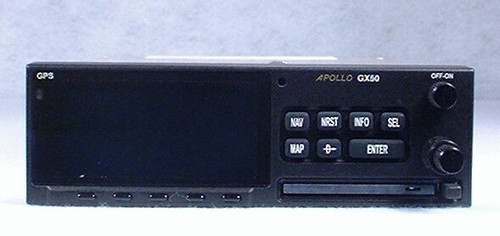
Apollo GX-50 IFR-Approach GPS / Moving Map
| Part Number: | P/N: 430-6050-400 |
| Part Number: | P/N: 430-6050-401 |
| Part Number: | P/N: 430-6050-402 |
| Part Number: | P/N: 430-6050-403 |
| Condition: | Serviceable (Certified Used) |
| Certification: | 8130-3 |
| Voltage: | 14/28 V |
| Included: | 90 Day Warranty |
| Included: | GPS Antenna, Rack, Connector, Existing Database available at extra cost if needed |
| Comments: | The factory has run out of replacement displays and we have a limited supply of spare parts. As a result, we no longer recommend this radio for new installations. |
| Comments: | Some of our GX-50 sales are for customers who are replacing another GX-50. These customers do not need the GPS antenna, mounting rack, or connectors, and we do not want to charge them for items they do not need. |
| Comments: | If you need these items for a new installation, please choose "Yes" in response to the "Need Installation Hardware" question. |
| Comments: | The GX-series database will be discontinued on December 3, 2020. It will not be possible to update the database after this date. |
Product Description
The II Morrow / Garmin AT Apollo GX-50 is a top-of-the-line GPS choice.
The Apollo GX-50 is an IFR non-precision approach certified GPS Receiver loaded with features, including a high-definition moving map display on a large sunlight viewable screen. The aircraft's position relative to airports, runways, VORs, NDBs, intersections, and special use airspace can be easily seen on the moving map. Operation is streamlined and pilot workload reduced through the use of Smart Keys and an intuitive interface. Airspace and navaids can be added or deleted from the map with a single press of the button.
The Apollo GX-50 features:
- Bright, clear electroluminescent display - This display measures 160 pixels wide by 80 pixels high, and its brightness is controlled automatically to match lighting conditions. This display can be set up to show a moving map, navigation information, and a graphical CDI.
- Moving Map graphics - The map shows your aircraft's position relative to surrounding database items. This map may be configured to use the full screen, or only part of it. In Full-screen mode, most of the display will show the map, but the corners are used to show the TO waypoint, bearing, distance, and map scale. In Split-screen mode, the display will also show ground speed, track, and cross track error. The map may be oriented with track up, desired track up, or magnetic north up. Map objects may be selected for information or "Direct To" navigation.
- Ease of use - The GX-50 uses Smart Keys to put the most commonly used features for a given operation right in front of the pilot. The Smart Key buttons are labeled right on the display. This makes it easy to access the GX-50's power, without crowding the faceplate with buttons. Simple navigation is available right away with the "Direct To" function. There is built-in simulation software for learning the rest of the features when you are safely on the ground, and can devote your full attention to training.
- Pilot-focused design - It is clear that this GPS was designed by pilots. A full complement of E-6B calculations are available. The GX-50 can receive altitude from encoder, and it knows the minimum safe altitude and enroute safe altitude for your flight. The navigation pages are user definable and have auto sequencing. The pilot may store up to 30 flight plans of 20 legs each, and these flights are flown with automatic waypoint sequencing. Up to 500 pilot defined waypoints may be added to the database. Automatic magnetic variation is based on your current position. The navigation computer has the ability to set up a parallel track offset. This unit also has both a countdown timer and a flight timer.
- Peace of mind - An Emergency Search function quickly displays the 20 nearest airports (other waypoint types are available as well). Even better, the pilot may set search criteria based on runway length, surface, and lighting. With search criteria, time isn't spent deciding about airports that can't be used. The GX-50 may also perform this search around any waypoint. This is useful to know what other airports are available near your destination.
- Datacard database - The GX-50 database stores comprehensive airport and navaid information. These database cards are front loading, which makes it much easier to keep the data up-to-date.
- Compatibility - The Apollo GX-50 may be interfaced with an HSI, CDI, Autopilot, Blind Encoder, Fuel Sensor, and external Moving Maps. Two RS-232 ports are provided.
The GX-50 provides non-precision guidance, without vertical information. Unless this GPS shares an Indicator which provides Glideslope, it is typically paired with a non-Glideslope Indicator:
- King KI-202 GPS/VOR/LOC Indicator
- Garmin GI-102A GPS/VOR/LOC Indicator
- Collins IND-350A GPS/VOR/LOC Indicator (later model with more durable metal case)
- Collins IND-350 GPS/VOR/LOC Indicator (not recommended)
 to send us an email.
 Loading... Please wait...


